Bridging the Gap – Impact of AutoCAD on the Sustainability of Rural Landscapes
Design is essential in creating an excellent urban infrastructure in an era of changing landscapes. AutoCAD’s role in connecting technology and the rural landscape is very high. Autodesk’s AutoCAD has brought many changes in design and architecture.
AutoCAD helps designers to make sustainable solutions for rural landscapes. Less population, limited resources, and a dependence on agriculture and natural resources often characterize these areas. Ensuring the long-term health and well-being of rural communities and the environment they depend on is a complex task. AutoCAD plays an essential role in addressing these challenges through innovative design solutions.
This blog gives you a study about how AutoCAD improved a rural community and improved its economy. It also helps learners to know the significant importance of AutoCAD, which can bring change in any environmental system with the help of design engineering.
Importance of using AutoCAD for construction in rural areas:
Many rural areas don’t have the facility to reach schools, shops, healthcare, and many service facilities due to the isolation of their landscape from rivers or unstructured landforms. Only a trail bridge can change the isolated community’s lives. Construction of 2D and 3D bridge structures using AutoCAD ensures more bridge safety and functionality, especially in rural areas with limited resources.
Trail bridge:
A trail bridge is designed to cross a waterway or any other rugged terrain by hiking or walking. Trail bridges reduce the distance to reaching a particular destination by circling a mountain or a village to get them.

Image: Trail bridge between two landscape
The usage of AutoCAD software helps in improving the material usage for the bridge construction. Most importantly in the rural areas where there are fewer resources and material utilization is challenging. Here is an example of the usage of design software that provided a way for the accessibility of education, healthcare, and other facilities in a place in Rwanda.
This suspended trail bridge helped 3,000 residents in a village near Kigali, Rwanda.
Three bridge designs were created using AutoCAD:

Image Courtesy: Bridges to Prosperity and Autodesk
Based on the topography of the selected location, three bridge designs namely suspended trail bridges with various material components were designed. The total cost taken for the construction of the bridge is $100,000 due to the difficult geographic location.
Structural Analysis of Suspended Trail Bridge:
The design engineers used the drafting tool and other structural analysis and simulation software. The significant advantage of using AutoCAD drawings is that these drawings can be integrated with any additional software to evaluate the bridge’s bearing capacity and structural integrity.
The efficiency of using AutoCAD with the local support team and supply chain management helped reduce the cost and provide a more substantial bridge infrastructure. Before initiating the structural analysis, the design engineers used Autodesk Robot to analyze the structure with the topographic survey data for the bridge construction.
Trail bridge design using AutoCAD:
Etienne, an AutoCAD engineer from Africa, joined Bridges to Prosperity after completing his civil engineering degree. Bridges to Prosperity is a non-profit organization that partners with local governments and communities to build trail bridges for rural villages.
If you are a beginner in AutoCAD, you can gain more experience and knowledge in real-time construction or engineering projects. After completing his internship, one of the AutoCAD experts joined Bridges to Prosperity as a project engineer. He performed significant topographic surveys for the installation of bridges in rural areas.
He learned to use AutoCAD for essential parts of the construction designs. He was a part of the trail bridge project in Rwanda that we have discussed previously. The AutoCAD experience and design gave him more flexibility and helped to complete the project in the calculated duration.
Three bridge model designs using AutoCAD:
The Bridges to Prosperity has created three bridge models for this project using AutoCAD. Based on the topography, they built a suspension trail bridge, a suspended trail bridge.
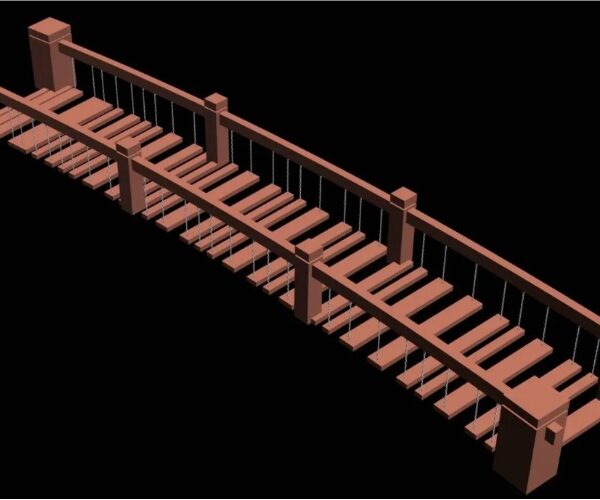
Image Courtesy: Plan and Design and a hybrid design.
The design is made based on the shape of the design valley. The bridge can raise the deck to avoid being washed away during the rainy seasons and floods. The structural analysis uses the materials available in the local areas where the trail bridge will be built. By creating designs in AutoCAD, the team can accurately construct the trail bridge according to the challenges in the site area.
Addition of new tools and technologies:
The impacts created through these remote infrastructure projects are high. New technologies like Fika Map can improve the infrastructures with the changing environment. Autodesk supports the Fika Map for the development of the major projects.
Fika Map is a revolutionizing tool used to scale bridges by conducting site identification audits, bridge assessments, and impact analysis at remote locations. With publicly available data, the transportation barriers can be overcome in the hard-to-reach spots. This improves the bridges’ structure and leads to the accessibility of various facilities for isolated communities in rural areas.
Learner’s perspective of the case study:
Using the Bridges to Prosperity trail bridge project, many takeaways are available for learners who are ready to start their journey in engineering design.
Precise design: AutoCAD helps the learners to know how precise 2D and 3D designs can be created at any complex location. Learning courses like Revit fundamentals, AutoCAD technician training, Autodesk Revit learning, and AutoCAD civil 3D certification help beginners know about the functionality of construction, especially in challenging areas.
Structural Analysis: AutoCAD is primarily a drafting tool that can be used with other structural analysis and simulation software. Beginners can learn to import AutoCAD drawings into specialized structural analysis software to evaluate the bridge’s load-bearing capacity and structural integrity.
Adaptability: AutoCAD allows for easy modifications to any design if changes or adjustments are needed during the project. This flexibility is more important, especially in unpredictable environmental or logistical challenges.
Assurance to Quality: AutoCAD can assist in maintaining design standards and following safety regulations, which is essential for the long-term life and safety of the bridge.
In Conclusion:
AutoCAD’s influence on rural landscape sustainability is highly effective and promising. This blog has explored how this powerful design tool has become more important for architects, urban planners, and landscape designers working in rural areas. AutoCAD has played a pivotal role in bridging the gap between modern design practices and improving rural landscapes through its ability to create effective planning processes, improve accuracy, and enhance communication.
AutoCAD enables professionals to create sustainable designs sensitive to the unique characteristics of rural environments. It helps them to strike a delicate balance between development and conservation, ensuring that rural landscapes remain functional and ecologically resilient. By utilizing AutoCAD’s capabilities, designers can integrate renewable energy solutions, optimize land use, and promote responsible resource management in rural areas.